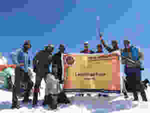
Lamkhaga Pass, a TRICKY PASS IN GARHWAL REGION
Lamkhaga Pass is the trickiest trek in the Garhwal region lying at an altitude of 5381 meters. And, it connects Himachal Pradesh’s Kinnaur to Harsil in Garhwal. This connecting pass is located near the Indo Tibetan border.
During Lamkhaga Pass, pass through some remote areas of Himachal and Garhwal with rich forests of Pine, Deodar, and Bhojpatra. Walk along the Jalindragad River till you reach the Kyarkoti meadows and further come across beautiful Baspa valley.
Also Read About – Deo Tibba Base Camp Trek – Best Trek in Manali, Himachal Pradesh

The starting point of Lamkhaga Pass is Harsil, a small town that is a tourist attraction. The trail is steep from the start but the variety of landscapes is rewarding. It is not suggested for beginners because of its tough gradient but turns great for experienced trekkers and mountaineers.
“Chitkul” the last village of Baspa Valley in Lamkhaga Pass
Chitkul is Baspa valley’s last village and there are beautiful wooden houses of villagers and cultivated green fields. Sangla valley lies further which is one of the best parts of Kinnaur.
This trek can be done from both the sides “Harsil” and “Chitkul”, but the Chitkul side is steeper. You will need ropes and proper equipment from both sides. So, explore the grandeur of Lamkhaga Pass
Best Time to do Lamkhaga Pass
So, the best time to do the trek is 2 st week of May to last week of October because in pre-monsoon the trail remains covered in snow and the climb gets tough. We are a local team in Uttarakhand so we have more experienced team Himalayan Hikers working this trek for 30 years


About the Harsil base camp of Lamkhaga Pass
Harsil is a picturesque town located on the banks of River Bhagirathi en route to Gangotri. It is a hidden gem in the Himalayas offering a tranquil environment and is best for people in search of tranquility. This small hamlet has become famous because of its natural beauty which highlights this area.
The dense Deodar forests, gushing Bhagirathi River, chirping of birds, high standing peaks makes this place perfect among nature lovers and trekking enthusiasts. Two high altitude Himalayan treks start from Harsil i.e. Lamkhaga Pass and Dhumdar Kandi Pass.
Why choose Lamkhaga Pass?
Before heading towards the itinerary, it is really essential to perceive the reason behind choosing Lamkhaga Pass.
See firstly, the trekking distance is a total of by taxi 231 Km and on foot 74 km which is to be covered into 9 days.
Dehradun to via Uttarkashi , Harsil To Chitkul market , Shimla.
Lamkhaga Pass is a high altitude mountain trek Altitudes is 5381 Meters.
The Starting trail is moderate as compared to other treks this is a difficult trek. So this trek is not for beginners.
Need proper gear & clothing for sub-zero temperature.
You got to see so many heavenly bodies at one place like the panoramic view of the Himalayan ranges, meadows,
one of the beautiful Harsil village trek on the way beautiful Kyarkoti camp pine forests, different variety of flora and fauna surpassing through bona fide Garhwali and Kinnaur heritage and culture.
I think Do spare time in Interaction with our local’s team, and you will get to know about some of the ancient tales of Indian mythology and our local cultures, this is good ideas for trekkers.
And, in summers, the Lamkhaga Pass turns totally different and amusing because of meadows, wildflowers, and woods blooming in different colures.
Beautiful landscapes so carry proper photo gear & Extra battery backup.
The backpack should not exceed 10 to 12 kg only.


The altitude we are going to cover in Lamkhaga Pass
Harsil – 2620 Meters
Laldevta camp – 3000 Meters
Kyarkoti Camp – 3480 Meters
Lamkhaga pass – 5381 Meters Gundar (4,415 Meter Dumti camp – 4035 Meter
Key Points of Lamkhaga Pass
Duration: – 8 Nights 9 Days – from Dehradun to Chitkul Village
Base camp: – Harsil Village
Summer Temperature: – Day ( 5°C to 10°C) Night (-2° C to 6° C)
Altitude: – 5381 Meter
Best Time: – May, June, September, October
Trek Level: – Difficult
Trek distance: – On foot 74 Km – By taxi 231 km Group Size: –10 to 12 people
Short Itinerary of Lamkhaga Pass Trek
Day 1:- Pick up to you from Dehradun railway station – Drive to Harsil – 231 km)( 9/10 Hours) (2620 Meter
Day 2:– Trek from Harsil to Lal Devta camp (07 km) (5/6 Hours) (3000 Meter )
Day 3:– Trek from Lal Devta camp to Kyarkoti (12 km) (6/7 Hours) (3480 Meter)
Day 4:- Trek From Kyarkoti to Lamkhaga base camp (11 km) (5/6 Hours) (4420 Meter)
Day 5:- Rest day for Acclimatization
Day 6:- Trek from Lamkhaga base camp to Lamkhaga Pass (5381 Meter) Dundhar camp (13 km) (7/8 Hours)
Day 7:- Trek from Dundhar camp to Dumti camp – (12 km) (4/5 Hours) (4035 Meter)
Day 8:- Trek from Dumti camp to rani Kanda – (09 km ) (4/5 Hours) (3638 Meter)
Day 9:- Trek from Rani Kanda to Chitkul Road head (10 km) (5/6 Hours) (3435 Meter )
Your Travel Plan for Lamkhaga Pass Trek
You can book trains, air flights, and bus tickets for your journey only according to the information given by us.
The Lamkhaga pass trek Duration will be of 8 days and 01 days of your journey from Dehradun to Harsil total of 09 Days from Dehradun to Chitkul
First of all, all the trekkers will have to book their flight and train bus according to our time table as our pick up is from 6 am to 7 am, you will have to reach Dehradun in the morning.
A taxi from Himalayan hikers will link you to the Dehradun railway station.
Himalayan Hikers organize transport to Harsil from the Dehradun railway station. Our vehicles leave at 6:00 am to 7:00 am sharp from Dehradun. The taxi costs include your package
At Dehradun railway station you will get our staff that will arrange transport for you. The contacts no Transport coordinator or our office team will give you a week ago to your departure
Please you guys book your transport facility according to your own time table, after Himalayan hikers take all the responsibility of Dehradun from Dehradun, that you will not face any problem.
How will you Reach Kedartal Trek?
If you are traveling from Kolkata, Bangalore, Chennai, Pune, Mumbai or Gujarat any other city, so you will have to come to Delhi, you will get a train from Delhi for Dehradun comfortably.
Option 01:- By Train
All trekkers booked yourself the
Nanda Devi Express to Dehradun (Train no is 12206 Departure 11:30 pm: – Reached Dehradun 5:45 am
Dehradun Express- to Dehradun (Train no is 12687 Departure -9:10 pm: – Reached Dehradun 5:00 am
Take both overnight trains Dehradun to from new Delhi- Dehradun Special A/C train from Hazrat Nizamuddin railway station the best option to you. The train reached at Dehradun railway station morning 5:45 to 6:30 am if you Meet to Our office Member – joining to our upcoming batches and Group.
Option 02:- By Air
Jolly Grant airport is the nearest airport in Dehradun. Located about 27 km for the Dehradun city. There are flights available from all states to Dehradun, you can go online and book your tickets. These are easy and easy ways for you and you also save your time, Taxis are available from the airport to Dehradun at all time costs Rs. 800/* one-way pay to directly
Option 03:- By Bus
You can reach Dehradun from Delhi by a bus, board it from (Delhi) Kasmiri get ISBT, it is good if you are booked the seats.
(Reach Dehradun Railway Station between 5:00 am to 6:00 am and the vehicle will be arranged from there.)
ATM Point and Mobile Connectivity in Lamkhaga pass Trek
ATM Point
Before starting the journey to Lamkhaga pass trek, make sure that you need payments, and then take out the cash on the way, Uttarkashi market is the last place where you can withdraw cash from ATM, (If you want to withdraw money then do it in Dehradun.)
Mobile Connectivity
The phone does not work on this trek. Therefore, you should ensure that you do not have to make any important calls. So make sure you finish all your important work and calls before starting the trek. Last Harsil Village, your device will receive good networks.
Comments
Post a Comment