Your trek journey started with Himalayan Hikers, the beautiful mountain town of Leh, all our trekkers reach Leh by flight this is the best option for your reach to Leh, altitude is 11400 feet above sea level, and the trek beautiful Zanskar River which liws totally frozen during the December to Feb, Peak Winters Trek, So, probably the best time to do Chadar Trek is February because the ice remains harsh and stable. Trek starts from the freezing point of the Zanskar River and that is Chilling.
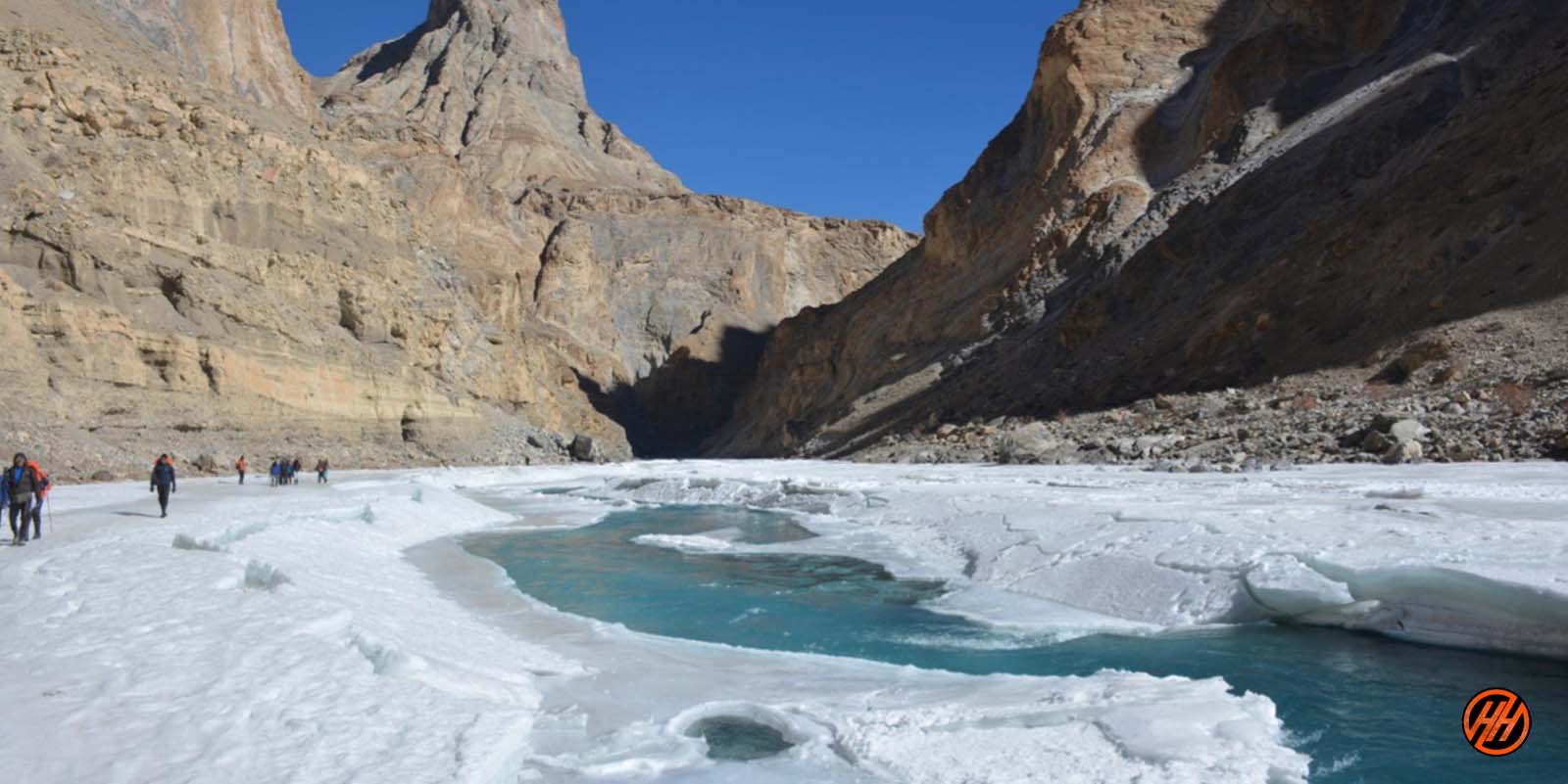
Therefore, the “Chadar trek” is also known as “The Frozen River Trek”. This Trek is over a frozen river in the Zanskar region of Ladakh and it is different from all other treks in the Himalayas.
The snow appears as a thick sheet of snow, therefore, it is called the “Chadar trek” and it is one of the trickiest treks in the world which is done in peak winter months. On this trek explore the Zankari culture and get to know about it in close proximity the main highlight of this Frozen River Trek is a completely frozen waterfall “Nerak”.
Ice Covering and Freezing Cold in Chadar Trek
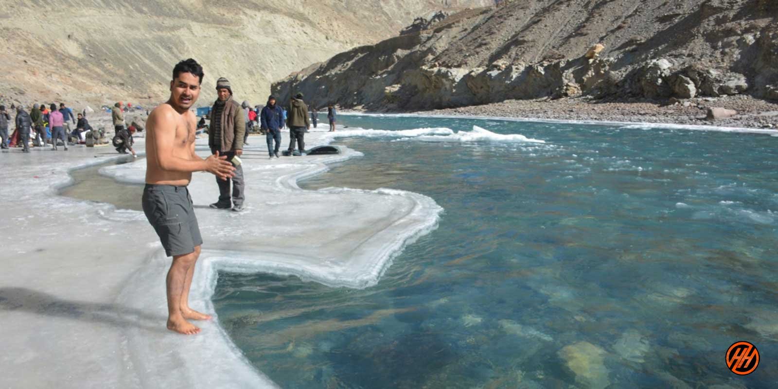
The Chadar trek is over a frozen river and the ice can turn dangerous sometimes but can also be safe the other times. But, it is important to find a safe path over the perilous sheet of ice.
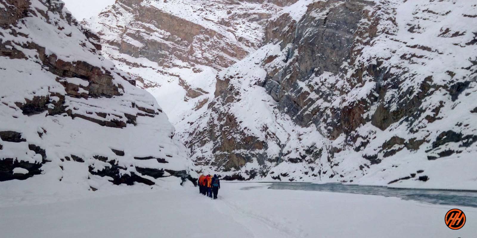
During the trek, you do not camp here at the meadows or the forest clearings but inside the caves which are present along the banks or you set up the tents on stable ice.
Here, the temperature remains chilly and freezing (-20) and falls down at night, so keep warm layers to protect the body against chilly cold and prevent the freezing of blood.
Be Aware During Chadar Trek (Not for Beginners)
You need to be very aware of the stability of ice and conditions below the feet for a safe trek. Sometimes the ice isn’t stable and the choices go wrong so walk carefully if suddenly a crack appears to go fast to the place where the ice is
So, choose a camping spot wisely after properly analyzing the area.
Here are some tips to do Chadar Trek –
- Analyze the ice sheet conditions.
- Avoid the cracks in the ice.
- Walk carefully on slippery areas.
- Run immediately to a stable area if a sudden crack appears under your feet.
- Walk on the places with a coating of snow.
- Choose camping spots wisely.
- Alcohol and smoking are not allowed during the trek
- Level- Difficult
- During the trek, proper conditioning & training of the body required
- Need proper gear & clothing for sub-zero temperature
- Shoes are the single most important piece of equipment.
- High Altitude requires proper acclimatization. Of base camp Leh
- Beautiful landscapes so carry good photo gear & Extra battery backup.
- Travel headlight
- The backpack should not exceed 12 kg.
- Long Gumboots are mandatory for all trekkers
Also Read About – Chaainsheel Bugyal Trek – The most beautiful ridge trek
About Leh – Ladakh – The Land of High Passes
- Area: 98,000sq km
- Altitude: 7,500m Max.
- Population: 250,000
- Religion: Buddhism, Islam. Hindu
- Geographical Status: Cold Desert
Across the Kashmir Valley and over the famous Zoji La pass lies Ladakh, the Land of High Passes. It is a magical land, so completely different from the green landscape of some other parts of the Himalayas. It is nature at its extreme. A land of freezing winds and blazing sunlight, Ladakh is a cold desert lying in the rain shadow of the Great Himalayas and other smaller ranges. Little rain and snow reach this dry area, where the natural forces have created a fantastic landscape.
Ladakh forms part of the state of Jammu and Kashmir in India. Parts of Ladakh are under the illegal occupation of Pakistan and China. The border of Ladakh touches those of Afghanistan, Pakistan, China, the Kashmir Valley (India), and Himachal Pradesh (India). This region is made up of two administrative districts — Leh District, with its headquarters at Leh, and Kargil District, with its headquarters at Kargil –and covers a total area of about 59,000 square kilometers.
Ladakh is at an average elevation of 2,700 m to 4,200 m. The aridity of this region is due to its location in the rainshadow area of the Great Himalayas, elevation, and radiation of heat from the bare soil. The most striking physical feature of Ladakh, however, is the parallelism of its mountain ranges. The region is extremely dry, with annual rainfall as low as 10 cubic centimeters.
In Ladakh, large rivers and their tributaries have carved deep gorges far below their steep banks. However, their water is not of much use as the terraced fields lie high above the gorges.
Until the advent of the aircraft, Ladakh could only be reached over dangerous, high passes. The Zoji La pass connecting Ladakh to Kashmir is 14,000 ft and is the lowest approach from the west. The southeast approach has to cross the 18,200 ft high Tanglang La. And to the north lie, the Saser La and the Karakoram pass, gateways to Central Asia from where trading caravans used to come for many centuries.
The altitude we are going to cover in Chadar Trek
- Leh – 3500 Meters
- Tsomo Paldar camp – 3200 Meters
- Tibb Cave camp – 3300 Meters
- Nerak camp – 3400 meters
ATM Point & Mobile connectivity in Chadar Trek
ATM POINT: Hi trekker ATM available in Leh Withdraw money before your journey,
Mobile Connectivity: There will be available all networks only postpaid
Key Points of Chadar Trek
- Duration: – 8 Nights 9 Days from Leh to Leh
- Base camp: – Leh
- Winter Temperature:- Day -5°C to -15°C) Night – 12° C to -20° C
- Chadar trek – Altitude: – 11400 feet
- Best Time: – Jan or Feb
- Trek Level: – Difficult
- Trek distance: – On foot 57 Km – By taxi 140 km
- Group Size: – minimum of 5 people maximum of 15 people
Temperature
The winter temp. touches as low as minus 30 degrees (Leh & Kargil) and minus 60 degrees in (Drass) subzero temp. prevails from December to February throughout Ladakh, whereas, zero-degree temp. is experienced during the rest of the winter months. This results in the freezing of all conceivable water resources. During summers the maximum temp. increases from 20 degrees C to 38 degrees C in July and August
Clothing: Light/Medium woolens in summer to Heavy woolens in winter
Languages Spoken
Ladakhi is the main language of Ladakh. Other languages spoken are Balti, Shina, Brokshat, and Changsha. In hotels and restaurants, staffs speak English and Hindi, while tour guides are well-versed in the language.
Key Points about Chadar Trek
– Level: Difficult (so first-timers trekkers should avoid)
– Proper conditioning & training of the body required
– Group size minimum of 05 and a maximum of 15 people
– Need proper Expedition gear & clothing for sub-zero temperatures?
– Shoes are the single most important equipment
– High Altitude requires proper acclimatization
– Phones don’t work on the trek, we provide to you Radio Walkie Talkie for Communication
– Beautiful landscape so carry good photo gear (I couldn’t carry my best equipment)
– Travel light (my backpack was heavy at about 12 kg to 15 Kg )
– Keep an extra day in your itinerary for attempt to Chadar trek summit account for bad weather
– Alcohol and smoking is not allowed in during the Chadar Trek Expedition
Difficulty level
Because the top is relatively high in elevation, we strongly recommend a reasonable level of physical fitness. The arduous journey of Chadar trek winter hiking with longer distances and ascending elevations to be covered in a short span of time would require acclimatization. We advise trekkers to physically and mentally prepare themselves prior to this trek. Throughout the course, all groups will be guided by our experts for trekking equipment and any impending terrain.
Any medical assistance that is required will be provided at any point of the journey; however, trekkers must consult their professional care before beginning any trek. We also strongly advise trekkers to learn about altitude sickness and to notify our teams as soon as any symptoms appear.
Short Itinerary of Chadar Trek
- Day 1:- Arrival at Leh – pickup to you from Airport drive to Hotel check in Rest and Acclimatization overnight stay Hotel
- Day 2:- Trek Planning and Briefing – Acclimatization and Preparation- meet us our Himalayan Hikers Guide overnight stay
- Day 3:- Medical Test Day in Leh
- Day 4:- Drive from Leh to Bakula (70 km) (2 hours) same Day Trek Bakula to Shingra Koma 2/3 Hours overnight stay Camp
- Day 5:- Trek from Shingra Koma to Tibba (16 km) (6/7 Hours) overnight stay Camp
- Day 6:- Trek from Tibba to Nerak Waterfall (12 km )( 6/7 Hours) overnight stay Camp
- Day 7:- Trek from Nerak to Tibba (16km ) (6/7 hours) overnight stay Camp
- Day 8:- Trek from Tibba to Bakula (12 km) (6/7 hours) Same day Drive to Leh Hotel
- Day 9:- After breakfast Depart from Leh
Permit and Passport
Tourist don’t require permit for Leh, however, all foreigners are required to be registered at Drass, Rumtse and Serchu if they are travelling overland. Those traveling by air get themselves registered at airport. Tourists are required to get permit for restricted areas like Tsomoriri, Tsokar and Pangong Lakes, Dhahanu and Nubra Valley, which can be obtained from District Magistrate, Leh, through Travel Agents at Leh.
Avoid acute mountain sickness
Acute mountain sickness can occur to any one at an altitude above 10,000 ft. above sea level, therefore, make it sure to take complete rest on the day of arrival.
How to Reach Leh or ladakh
Overland Approach
Overland Approach – The overland approach to Ladakh from Kashmir Valley via Kargil is approx. 434 Km, which remains open for traffic from early June to November. The most dramatic part of this road journey is the ascent up the 11,500 feet / 3,505 m high Zoji-La, the pass in the Great Himalayan Wall that serves as the gateway to Ladakh. The J & K State Road Transport Corporation (J&K SRTC) operates regular Deluxe and Ordinary bus services between Srinagar and Leh on this route with an overnight halt at Kargil. Taxis (cars and jeeps) are also available at Srinagar for the journey. Groups can charter Deluxe and A-class buses for Leh, Kargil or Padum (Zangskar) from the J & K SRTC at Srinagar.
Manali to Leh – Since 1989, the 473 km. Manali-Leh road has been serving as the second overland approach to Ladakh. Open for traffic from around mid-June to early October. This high road traverses the upland desert plateau of Rupsho, altitude ranges from 3,660m to 4,570m. A number of high passes fall enroute among which the highest one known as Taklang-La is world’s second highest motorable pass at an altitude of 17,469 feet/5,235m. Himachal Pradesh Tourism, HRTC and J & K SRTC operate daily Deluxe and Ordinary bus services between Manali and Leh. The bus journey between Leh and Manali takes about 19 hours or two days with an overnight halt in camps at Serchu or Pang. Shared taxis are also available both from Leh and Manali
Road Distances
- Srinagar-Leh 434 Km
- Manali-Leh 473 Km
- Srinagar-Kargil 204 Km
- Delhi-Leh 1047 Kms
- Leh-Kargil 234 Km
- Kargil-Padum (Zanskar) 240 Km
- Leh-Deskit (Nubra Valley)118 Kms.
Credit Cards & ATM Machine
Credit cards are accepted by very few hotels and tour operators but there will be 2.5% service charge. The Jammu and Kashmir Bank and State Bank of India has placed ATM Machine in Leh. The State Bank of India accepts visa and mastero but this ATM is not very reliable. J&K Bank ATM is more reliable but accepts only Mastero.
Air Travel
Indian Airlines http://www.indian-airlines.nic.in operates regular flights to Leh from Delhi (fare USD 135), Four flights in a week from Jammu and once in a week from Chandigarh and twice from Srinagar. Jet Airways http://www.jetairways.com also operates daily flights between Leh-Delhi (fare USD 143).
Internal Transport
The cheapest way to travel within the region is by public buses, which ply on fixed routes according to fixed time schedules. The most comfortable and convenient though expensive mode of travel, however, is by taxi, which are available for hire on fixed point-to-point tariff. For visits to the newly opened areas of Nubra, Dah-Hanu, Tsomoriri, Tsokar and Pangong Lakes. It is mandatory to engage the services of a registered/recognized travel agency for making all the requisite arrangements including internal transport. Detailed information about bus schedules, taxi tariff, travel agencies can be obtained from the Tourist Office or Local travels guide “Reach Ladakh”, available at Book Shops.
Leh is the headquarter of Leh District, and the largest town of the region. It is located to the north of the Indus River at an elevation of 3600m above the sea level. The town is dominated by the nine-storey Namgyal Palace and Namgyal Tsemo (victory peak), built by Tashi Namgyal on his victorious in reunification of the Upper and Lower Ladakh. Leh became the capital of Stod (upper Ladakh) during the reign of king Graspa Bum- Lde,who ruled Ladakh from 1400 to 1430 AD. In the later period, Leh became an important center for trade in Central Asia. Leh remained merely a headquarter of Ladakh district until 1974, when Ladakh was opened for foreign tourists. Since then period Leh became the centre for tourism related activities in the region.
Fact File
Leh provides medium and lower class accommodation, with hundreds of guesthouses and hotels, which can suite every budget. Restaurants offer good multicuisine for a reasonable price. There are number of tour Operator/Travel Agents around the town, which look after traveler’s requirements.
Tour of Buddhist monasteries can be organised in one or two days, as all the famous monasteries are within a drive of one or two days from Leh. For information on monasteries please check monastery section of this web site.
Comments
Post a Comment